
| Home | Features | ECW | Download | Purchase | Contact |
| What is ECW? | |||||||||||||||||||||||||||||
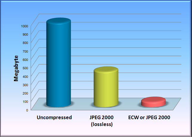
| Enhanced compression wavelet
(ECW) is a high-performance compressed file format designed
specifically for geospatial imagery. When compared to other
image compression formats, Intergraph (ERDAS) patented ECW
technology provides the industry’s fastest decompression and
compression rates possible. Remarkably, this is done without
placing a heavy load on computer memory and processors, while
also maintaining high compression ratios and visually lossless
image quality. ECW has become the de facto industry standard for rapidly handling large geospatial imagery. |
|
||||||||||||||||||||||||||||
| Why use ECW? | |||||||||||||||||||||||||||||
|
|||||||||||||||||||||||||||||
| ECW is supported in industry's most popular desktop GIS, CAD and remote sensing packages, including GeoMedia®, ArcGIS® for Desktop, AutoCAD®, Blue Marble Desktop®, ENVI®, Geomatica®, LizardTech®, GeoExpress®, FalconView™, Global Mapper, MapInfo®, Manifold® System, MicroStation®, and Smallworld™. ECW support is also available when using open source geospatial packages such as GeoServer and MapServer | |||||||||||||||||||||||||||||
| Reference: | |||||||||||||||||||||||||||||
| ECW format resources on the Hexagon Geospatial website | |||||||||||||||||||||||||||||
| [Link to German ECW website] | |||||||||||||||||||||||||||||
|
||
|
|
GEOSYSTEMS GmbH - Friedrichshafener Str. 1 - D-82205 Gilching - Germany Web: www.geosystems.de - E-Mail: info@geosystems.de |
|